Giới thiệu về tài nguyên nước và nhu cầu sử dụng nước
Questions
- What are the relative merits of using surface water vs. groundwater as a water resource?
- Why is society facing a crisis involving water supply and how can we solve it?
Giới thiệu chung về tài nguyên nước
Phân bố nước toàn cầu
](https://d9-wret.s3.us-west-2.amazonaws.com/assets/palladium/production/s3fs-public/thumbnails/image/EarthsWater-BarChart.png)
Phân bố lượng mưa toàn cầu
](https://d9-wret.s3.us-west-2.amazonaws.com/assets/palladium/production/s3fs-public/thumbnails/image/wss-cycle-precipitation-world-map.gif)
Tài nguyên nước ngầm
Các đặc trưng của nước ngầm
](https://d9-wret.s3.us-west-2.amazonaws.com/assets/palladium/production/s3fs-public/thumbnails/image/wss-gw-how-groundwater-occurs-diagram.png)
Dòng chảy nước ngầm
](https://d9-wret.s3.us-west-2.amazonaws.com/assets/palladium/production/s3fs-public/thumbnails/image/wss-cycle-groundwater-flow-diagram.jpg)
Giếng Artesian
](https://d9-wret.s3.us-west-2.amazonaws.com/assets/palladium/production/s3fs-public/thumbnails/image/wss-gw-artesian-diagram.png)
Sự tương tác của nước ngầm và dòng chảy nước mặt
](https://pubs.usgs.gov/circ/circ1186/images/fig12.gif)
Các vấn đề về khai thác tài nguyên nước ngầm
Khai thác quá mức nước ngầm dẫn đến hạ thấp mực nước ngầm
](https://d9-wret.s3.us-west-2.amazonaws.com/assets/palladium/production/s3fs-public/thumbnails/image/drawdown_0.png)
Cone of depression: Pumping a well can cause water level lowering. Source: United States Geological Survey Khai thác quá mức nước ngầm ở ven biển dẫn đến tăng cường xâm nhập mặn
](https://pubs.usgs.gov/gip/gw/images/Intrusion.gif)
How intensive ground-water pumping can cause salt-water intrusion in coastal aquifers. Source: United States Geological Survey Khai thác quá mức nước ngầm có thể gây sụt lún (land subsidence) và hố sụt (sinkhole)
](https://d9-wret.s3.us-west-2.amazonaws.com/assets/palladium/production/s3fs-public/media/images/AquiferCompaction_508Blue_crop_4mg_0.gif)
Aquifer compaction and land subsidence. Source: United States Geological Survey
Đồng bằng Sông Hồng, Đồng Bằng Sông Cứu Long, và một số đồng bằng ven biển có nguy cơ sụt lún:, [Map](https://info.igme.es/visor/?Configuracion=globalsubsidence&idioma=en)](/onlinecourse/course/suscc/3_resources/3_resources_subsidence_hu_606a3e495557fc42.webp)
Nhu cầu sử dụng nước
Nhu cầu sử dụng nước ngày càng tăng
](https://farm1.staticflickr.com/674/32363106455_feaa116cae_b.jpg)
Bản đồ hiện trạng sức ép tài nguyên nước (baseline water stress) theo WRI, 2023. Aqueduct 4.0
Source: WRI, 2023. Aqueduct 4.0 Current and Future Global Maps Data
Description of Baseline water stress
Baseline water stress measures the ratio of total water demand to available renewable surface and groundwater supplies. Water demand include domestic, industrial, irrigation, and livestock uses. Available renewable water supplies include the impact of upstream consumptive water users and large dams on downstream water availability. Higher values indicate more competition among users.
Bản đồ sức ép tài nguyên nước tương ứng với các kịch bản biến đổi khí hậu tương lai theo WRI, 2023. Aqueduct 4.0
Source: WRI, 2023. Aqueduct 4.0 Current and Future Global Maps Data
Description of Water stress - future projections (2030-2050-2080)
Water stress is an indicator of competition for water resources and is defined informally as the ratio of demand for water by human society divided by available water. Future projections are available for 3 long-term trends over a 30 year period (2015-2045, 2035-2065, 2065-2090) and 3 scenarios (Optimistic, Business as usual, Pessimistic).
Optimistic: The “optimistic” scenario (SSP1 RCP2.6) represents a future that limits the rise in average global surface temperatures by 2100 to 1.3°C to 2.4°C compared to preindustrial levels (1850-1900). SSP1 is characterized by sustainable socioeconomic growth: stringent environmental regulations and effective institutions, rapid technological change and improved water use efficiencies, and low population growth.Business as usual: The “business as usual” scenario (SSP3 RCP7.0) represents a middle-of-the-road future where temperatures increase by 2.8°C to 4.6°C by 2100. SSP3 is a socioeconomic scenario characterized by regional competition and inequality, including slow economic growth, weak governance and institutions, low investment in the environment and technology, and high population growth, especially in developing countries.Pessimistic: The “pessimistic” scenario (SSP5 RCP8.5) represents a future where temperatures increase up to 3.3°C to 5.7°C by 2100. SSP5 describes fossil-fueled development: rapid economic growth and globalization powered by carbon-intensive energy, strong institutions with high investment in education and technology but a lack of global environmental concern, and the population peaking and declining in the 21st century.
Các giải pháp sử dụng nước bền vững
Hồ chứa nhân tạo và đập thủy điện
Tuy nhiên, đập thủy điện cũng có những hạn chế cần xem xét.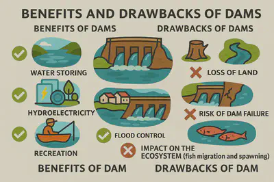
Khử mặn nước biển
Hiện tại các công nghệ khử mặn nước biển có chi phí cao và yêu cầu hạ tầng quy mô lớn, tiêu tốn năng lượng.
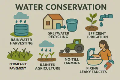
Bảo tồn tài nguyên nước (water conservation)